Project P7:
The application of time in closure as a novel strategy towards error-free space geodetic observations
Project overview
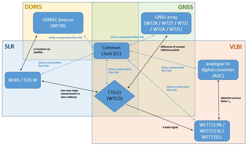
P7 focuses on the improvement of space geodetic techniques by exploiting the common space-time reference point realised at the Geodetic Observatory Wettzell (GOW). Its scope includes GNSS, SLR, VLBI and DORIS, whose observations support navigation, precise satellite orbits, Earth-system monitoring and reference-frame determination.
SLR contributes the reference frame’s origin and, together with VLBI, its scale. GNSS and DORIS are central to positioning and satellite orbit determination. Unknown instrumental and modelling effects affect all techniques. P7 investigates time-related, technique-specific and system-dependent errors through closure measurements to a common target, with the aim of separating instrumental effects from atmospheric propagation delays.
Why it matters
How can the full measurement chain be checked independently of the parameters estimated in data analysis?
Geometric surveys locate instrument reference points but do not reveal every delay along the signal paths. Independent closure checks are needed to identify effects otherwise absorbed by clock or other fitted parameters.
Our approach
Calibration and analysis are brought together through measurements to the shared target and comparisons with terrestrial surveys. A central aim is to transfer the approach from laboratory tests to routine observations. Close exchanges with P1, P6, P8, P9 and P10 support the diagnosis of instrumental, geometric and atmospheric contributions.
Key outcomes
- Reprocessed laser-ranging calibration observations to the first common target, confirming an unresolved discrepancy of approximately 5 mm relative to terrestrial measurements.
- Identified satellite-dependent signatures in SLR range biases, showing that the remaining effects cannot all be assigned to changes in the ground telescope.
- Analysed telescope-specific VLBI clock corrections and common-clock observations to expose residual signals and guide further compensated-timing experiments.
- Refined the validation strategy to combine continuous target monitoring by GNSS, renewed survey evaluation and meteorological observations.
The work provides a clearer diagnosis of the limits of closure measurements. The remaining target bias is an open calibration question. Related published work on submillimetre satellite-orbit comparison helps avoid numerical artefacts during observation validation.
Publications:
- Zeitlhoefler J., Blossfeld M., Rudenko S., Dettmering D., Seitz F.: Station-dependent satellite laser ranging measurement corrections for TOPEX/Poseidon. Advances in Space Research, 71(1), 975-996, 10.1016/j.asr.2022.09.002, 2023
- Zeitlhoefler J., Alkahal R., Rudenko S., Blossfeld M., Seitz F.: Performance assessment of interpolation methods for orbits of altimetry satellites. Earth, Planets and Space, submitted, 2024