Phase 2: From coherent time to a network of observatories
The second funding phase will bring clocks, calibrated links and geodetic analysis into a traceable measurement chain and test it across several observatories.
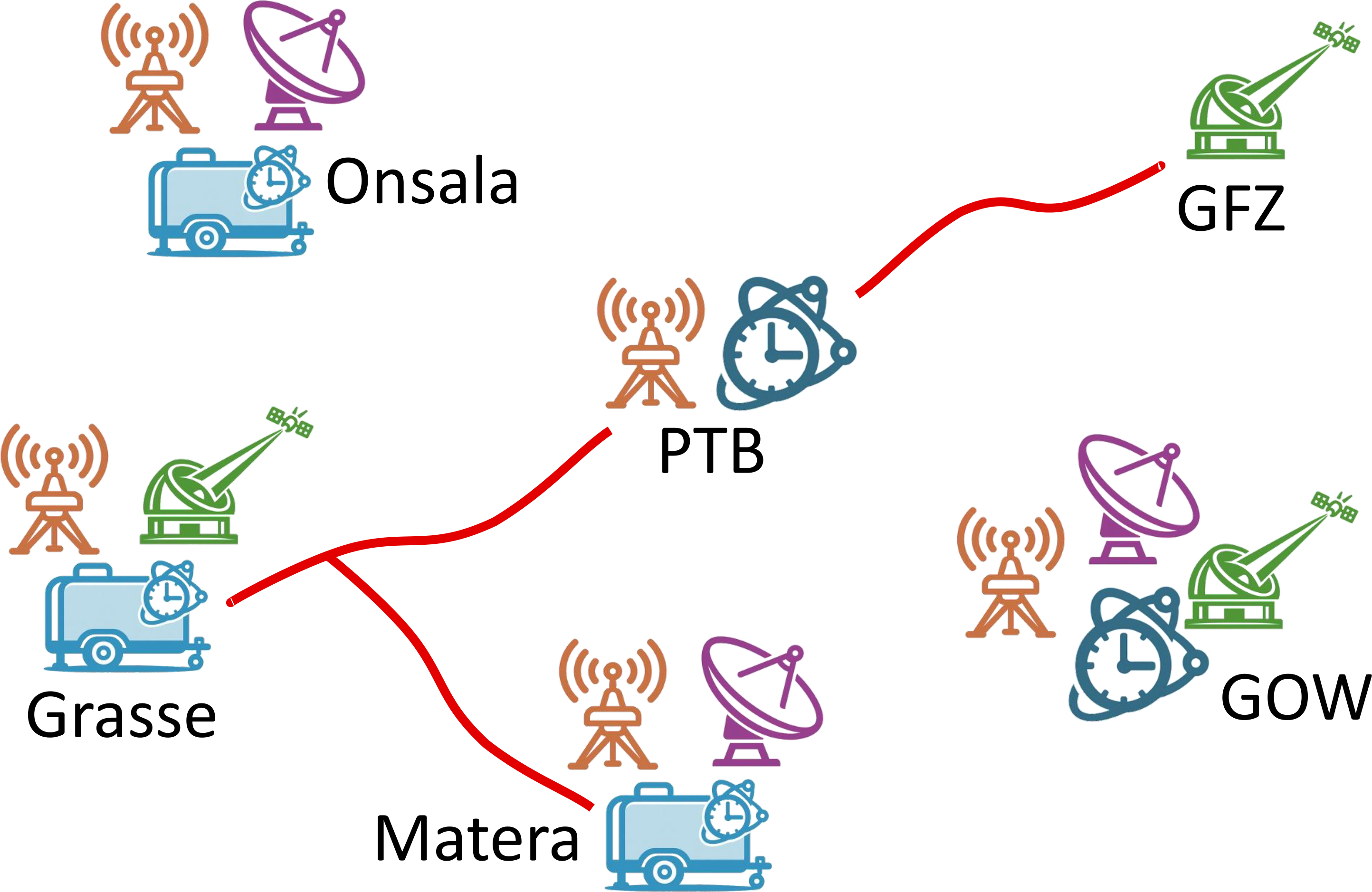
Phase 1 established the experimental and analytical foundations. Phase 2 will integrate these components and evaluate their impact on geodetic accuracy, long-term stability and the connection of geometric and physical reference systems. Coordinated campaigns at Grasse, Onsala and Matera will test whether the concepts developed at Wettzell can be transferred reproducibly to other observatories.
Why it matters
Can independently characterised clocks and calibrated signal paths measurably improve geodetic products?
Time-variable instrumental effects can be absorbed into estimated clock, atmospheric and coordinate parameters. Independently observing those effects should help separate them. Optical clocks also measure gravity-potential differences, adding physical information to geometric observations.
Key concepts
Coherent time as a dynamic physical tie. A shared reference, actively delay-compensated links and closure measurements make changes in instrumental delays observable.
Optical clocks as gravity sensors. Relativistic frequency comparisons provide independent gravity-potential differences for chronometric levelling and reference-system integration.
Two complementary optical clocks. SOC2 is planned as the persistent optical reference at Wettzell. PTB's transportable strontium clock Sr4 will bring accurate frequency references to partner observatories.
Independent links and one relativistic framework. Fibre, calibrated GNSS, optical and microwave links will cross-check one another. A common relativistic description will support their interpretation.
How the projects interact
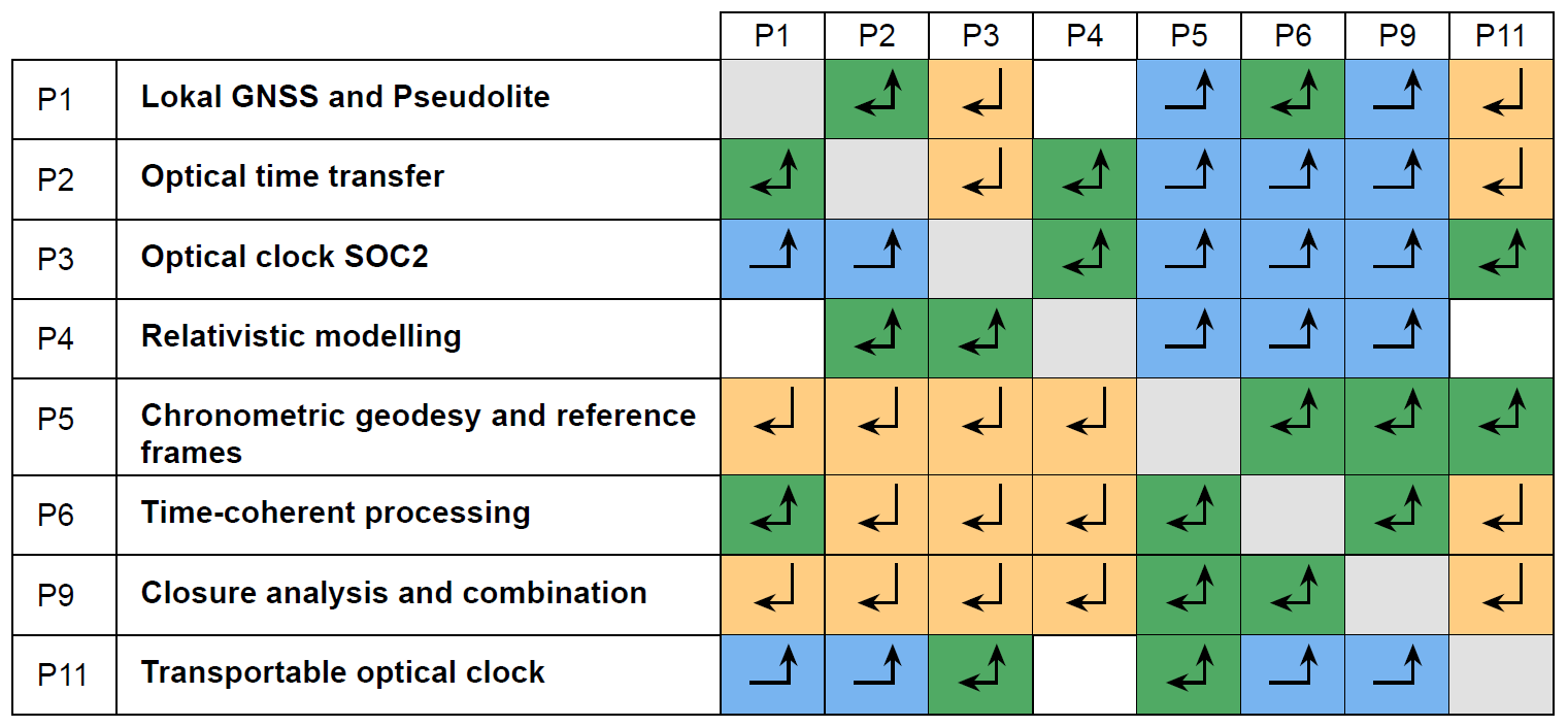
P1, P2, P3 and P11 will provide the experimental capabilities. P4 will provide the relativistic framework. P5, P6 and P9 will exploit the shared observations. Closure results and analysis will feed back into calibration and experiment design.
Five objectives
- O1: Traceable ties through time. Characterise complete GNSS, SLR and VLBI signal paths and transfer the concept beyond Wettzell.
- O2: Reliable and stable geodetic products. Quantify when clock information can constrain or replace estimated clock parameters and improve the resulting products.
- O3: Connect physical and geometric reference systems. Combine clock-derived potential and height differences with geometric observations, including a VLBI chronometric-levelling proof of concept.
- O4: Relativistic models and tests. Describe ground and space clock networks consistently and support tests of gravitational redshift and other accessible relativistic effects.
- O5: Separate residual effects. Identify atmospheric, instrumental, orbital and technique-specific contributions and quantify their reduced correlations.
Three coordinated campaigns
- Grasse: Compare independent fibre, satellite-laser and calibrated GNSS clock links, supporting chronometric heights and multi-technique analysis.
- Onsala: Test independently characterised optical references on a long VLBI baseline and explore VLBI chronometric levelling.
- Matera: Extend the chronometric network into southern Europe and test transferability at another multi-technique observatory.
Eleven planned tasks
| Task | Planned work |
|---|---|
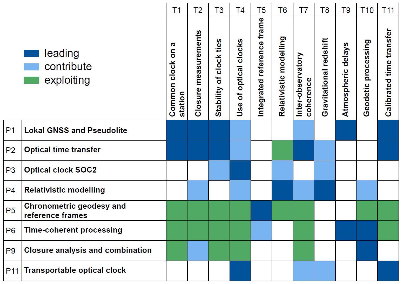
| T1 | Establish a common, consistent time-coherent tie between the major space-geodetic techniques at Wettzell. |
| T2 | Develop and validate closure measurements for VLBI, SLR and GNSS, including space-borne common space-time targets. |
| T3 | Evaluate the long-term stability of clock ties within and across Wettzell's measurement systems. |
| T4 | Use accurate optical clocks in space geodesy and include them in clock ties. |
| T5 | Combine geometric and physical quantities towards an integrated reference frame. |
| T6 | Develop and apply relativistic models of global coherent time using linked ground and space clocks. |
| T7 | Extend time and frequency coherence to other observatories through local or transportable clocks, fibre links or satellite links. |
| T8 | Use satellite time transfer and fibre frequency transfer for gravitational-redshift tests. |
| T9 | Use accurate clock information to isolate atmospheric propagation delays and reduce parameter correlations and systematic effects. |
| T10 | Evaluate synchronised, highly accurate clocks in geodetic processing and terrestrial reference-frame solutions. |
| T11 | Apply calibrated geodetic measurement techniques to time and frequency transfer between ground stations. |
Projects at a glance
The proposed structure consolidates ten Phase 1 projects into eight. P1-P6 and P9 continue. Activities from P7, P8 and P10 are integrated into P5/P9, P1/P6 and P6, respectively. P11 adds the transportable optical clock.
| Project | Planned focus |
|---|---|
| P1 | Calibrated GNSS Infrastructure for High-Accuracy Time Transfer Continuous pseudolite and receiver-delay calibration, IPPP processing and a transportable calibration system. |
| P2 | Long distance optical time transfer from ground to ground via satellite links ACES optical and microwave comparisons, passive optical targets and links to the Lunar Orbiting Clock. |
| P3 | Operation of the optical clock "SOC2" in Wettzell, performance optimization and application to geodetic leveling, VLBI, and fundamental physics studies Operate and improve the stationary optical reference and use it in clock-comparison and geodetic experiments. |
| P4 | General Relativity and coherent time Relativistic consistency, clock synchronisation, link modelling and precision tests. |
| P5 | Impact of clock networks on physical heights and reference frames Determine physical-height differences from clock networks and integrate them with geometric reference information. |
| P6 | Integrated Clock, Orbit, and Atmosphere modelling for Enhanced Geodetic Products (COAT) Joint clock, atmosphere, orbit and multi-technique modelling for more consistent geodetic products. |
| P9 | The application of novel time-in-closure strategies towards error-free space geodetic observations and their combination Common-target closure and local and inter-observatory clock combination for GNSS, SLR, VLBI and reference-frame analysis. |
| P11 | Chronometric levelling with fibre-linked optical clocks Transportable-clock campaigns, fibre-linked frequency comparisons and centimetre-resolution chronometric levelling. |
How progress will be tested
The same observations will be processed conventionally and with independently characterised clocks, clock ties and calibrated delays. Closure residuals and comparisons of independent links will assess remaining biases. Geodetic solutions will be compared through uncertainties, correlations, temporal stability and changes in coordinates, atmosphere, orbits, Earth orientation and reference-frame parameters. Long-baseline VLBI phase-delay studies are planned as an additional proof of concept.
Planned outcomes
- A validated, traceable measurement and analysis chain extending from clocks to geodetic products across several observatories.
- Quantified benefits and limitations of coherent time for calibration, geodetic accuracy and long-term stability.
- Clock-derived physical-height information that strengthens the connection between physical and geometric reference systems.
The programme will test these advances through shared campaigns and independent measurement paths, with the emphasis on demonstrated performance under real observing conditions.