Project P10:
Combination of Space Geodetic Techniques with Clock Ties and Atmospheric Ties (COCAT)
Project overview
P10 aims to improve the International Terrestrial Reference Frame (ITRF) through a multi-technique combination. It develops advanced atmospheric-delay modelling and atmospheric ties at co-located sites, with particular attention to the clock strategies and calibrated clock ties being developed at Wettzell.
The ITRF combines GNSS, VLBI, SLR and DORIS. Geometric local ties and shared Earth-orientation parameters connect their solutions, but remaining discrepancies and limitations of the ties restrict the achievable accuracy. Atmospheric delays, clocks and station coordinates are strongly correlated. COCAT therefore investigates how more consistent modelling and additional constraints on atmospheric and clock parameters can strengthen the combination.
Why it matters
How can atmospheric and clock information make multi-technique reference-frame solutions more consistent?
More precise instruments alone cannot remove correlations or inconsistent modelling between techniques. Shared atmospheric and clock information can help separate the effects that would otherwise enter coordinates or other geodetic parameters.
Our approach
The project studies atmospheric delays at global stations, clock behaviour within and between techniques, and the use of their ties in a common estimator. Observation-level GPS–VLBI processing provides a practical test, complemented by GNSS studies of loading, receiver clocks, coordinates and satellite orbits.
Key outcomes
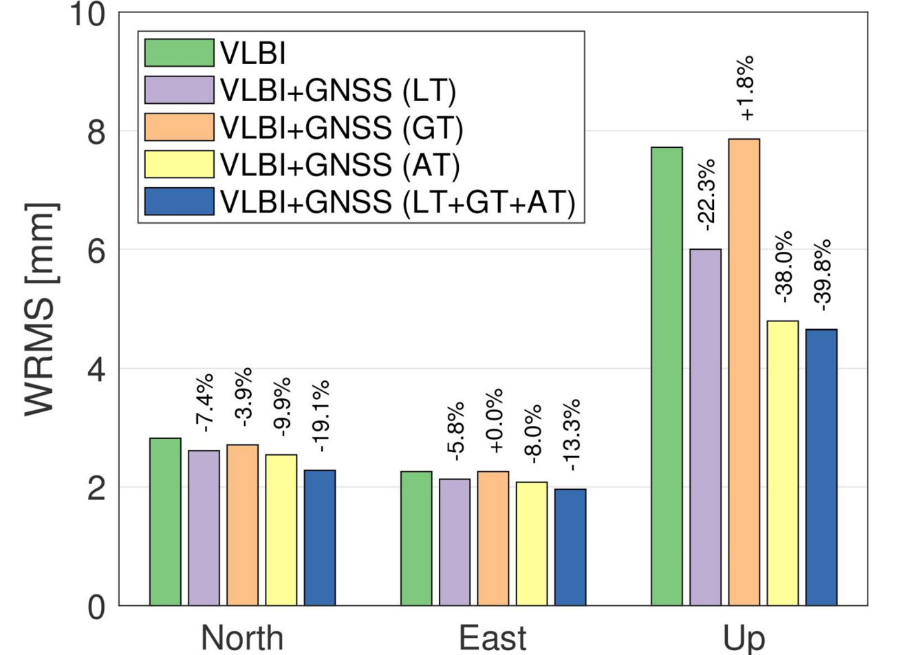
- Realised integrated GPS–VLBI processing for five continuous observing campaigns. Combined tie strategies improved VLBI coordinate repeatability by up to 20% horizontally and 30% vertically.
- Showed that correcting non-tidal atmospheric and oceanic loading during GNSS processing improves coordinate repeatability by about 3–4% horizontally and 13% vertically compared with uncorrected solutions.
- Demonstrated that receiver-clock estimates absorb non-clock effects, including high-frequency loading signals, so their interpretation requires consistent geophysical modelling.
- Tested clock ties in combined analysis. Real-data solutions showed better atmospheric-delay consistency, but remaining inter-technique clock discrepancies still limited improvements in station coordinates.
The results demonstrate the value of observation-level combination and identify the next calibration requirements. Atmospheric and geometric ties already yield measurable gains. Fully exploiting clock ties also requires stable, characterised instrumental delays.
Publications:
- Wang, J., Ge, M., Balidakis, K., Glaser, S., Heinkelmann, R., Schuh, H. (2025) Integrated Processing of GPS and VLBI at the Observation Level. Journal of Geodesy, 99, 60. doi.org/10.1007/s00190-025-01984-0
- Du, S., Cui, B., Tang, L., Wang, J., Huang, G., Schuh H. (2025) Enhancements of triple-frequency signals and multi-constellation combinations in PPP-RTK Services: improving convergence speed and expanding service coverage. GPS Solut, 29, 126. doi.org/10.1007/s10291-025-01883-z
- Wang, J., Balidakis, K., Dobslaw, H., Maennel, B., Ge, M., Heinkelmann, R., Schuh, H. (2025). Correcting non-tidal atmospheric and oceanic loading displacements at the observation, normal equation, and parameter levels in GNSS Data analysis. Journal of Geophysical Research: Solid Earth, 130, e2024JB030299. doi.org/10.1029/2024JB030299
- Ding, J., Chen, W., Chen, J., Wang, J., Zhang, Y., Bai, L. (2025) Real-time high-resolution global PWV retrieval based on weather forecast foundation models and cross-validation with radiosonde, GNSS, and ERA5. IEEE Journal of Selected Topics in Applied Earth Observations and Remote Sensing. doi.org/10.1109/JSTARS.2025.3580782
- Ding, J., Chen, W., Chen, J., Wang, J., Zhang, Y., Bai, L., Wang, Y., Mi, X., Liu, T., Wenig, D. (2025) Spatiotemporal inhomogeneity of accuracy degradation in AI weather forecast foundation models: A GNSS perspective. International Journal of Applied Earth Observation and Geoinformation, 139. doi.org/10.1016/j.jag.2025.104473
- Wang, J., Chen, J., Zhang, Y. (2025) Empirical modeling of tropospheric delays and uncertainty. Geoscientific Model Development, 18, 1487-1504. doi.org/10.5194/gmd-18-1487-2025
- Yuan, P., Balidakis, K., Wang, J., Xia, P., Wang, J., Zhang, M., Jiang, W., Schuh, H., Wickert, J., Deng, Z. (2025). Deep neural networks for refining vertical modeling of global tropospheric delay. Geophysical Research Letters, 52. doi.org/10.1029/2024GL111404
- Cui, B., Wang, J., Li, P., Hu, J., Zuo, X., Tang, L. (2025). Modified ionosphere delay fitting model with atmosphere uncertainty grids for wide-area real-time positioning. Geo-Spatial Information Science, 1-19. doi.org/10.1080/10095020.2024.2440091
- Nie, L., Wang, J., Tang, L., Ge, H., Ge, M., Schuh, H. (2025). Impact of LEO configuration on GPS precise orbit determination with un-differenced ambiguity resolution. GPS Solut, 29, 28. doi.org/10.1007/s10291-024-01791-8
- Ding, J., Mi, X., Chen, W., Chen, J., Wang, J., Zhang, Y., Awange, J., Soja, B., Bai, L., Deng, Y., Tang., W. (2024). Forecasting of Tropospheric Delay Using AI Foundation Models in Support of Microwave Remote Sensing. IEEE Transactions on Geoscience and Remote Sensing, 62, 1-19. doi.org/10.1109/TGRS.2024.3488727
- Ding, J., Chen, J., Wang, J., Zhang Y. (2024). A novel method for tropospheric delay mapping function vertical modeling. J Geod, 98, 37. doi.org/10.1007/s00190-024-01845-2