The application of time in closure as a novel strategy towards error-free space geodetic observations (P7)
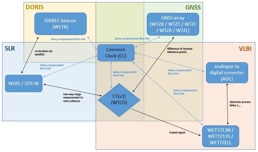
P7 focuses on the improvement of space geodetic techniques by exploiting the common space-time reference point realized at the Geodetic Observatory Wettzell (GOW).

The project analyses the four major space-geodetic techniques (GNSS, SLR, VLBI, DORIS) whose observations are used for a broad variety of scientific and societal applications, such as the monitoring of geodynamics and global change phenomena or positioning and navigation. Besides, especialy SLR and VLBI play a fundamental role for the realization of the geodetic datum of the International Terrestrial Reference Frame (ITRF). In this context, SLR is used for the realization of the ITRF long-term mean origin and, together with VLBI, for the realization of the ITRF scale. GNSS is fundamental for navigation and positioning for ground-based applications as well as, in combination with DORIS, for the precise orbit determination of satellites.
All space-geodetic techniques still suffer from unknown systematic instrumental (measurement) or modelling errors which requires the estimation of parameters which absorb those errors. P7 aims to separate and compensate these time-related, technique-specific, and system-dependent errors by performing "closure in time" experiments to a common target at the GOW. Another key task of P7 is the investigation of the technical aspect of time coherence at GOW by realizing the calibration of measurements and methods to the common target not only in laboratory setups but also in a measurement mode during routine operations.
The experiments will enable the separation of instrument-related effects and atmospheric signal delays. This task is closely linked with the RU's projects P8 (Physical Atmosphere) and P10 (Clock and Atmospheric Ties). Project P7 is also interconnected with several other projects of the RU by providing or receiving data. The knowledge gained will be used to perform additional experiments to a second common target which will provide site-related measurement systematics at GOW. The detected residual errors will be analysed and removed to obtain improved measurements of all geodetic-space techniques.
Publications:
- Zeitlhöfler J., Bloßfeld M., Rudenko S., Dettmering D., Seitz F.: Station-dependent satellite laser ranging measurement corrections for TOPEX/Poseidon. Advances in Space Research, 71(1), 975-996, 10.1016/j.asr.2022.09.002, 2023
- Zeitlhöfler J., Alkahal R., Rudenko S., Bloßfeld M., Seitz F.: Performance assessment of interpolation methods for orbits of altimetry satellites. Earth, Planets and Space, submitted, 2024