Combination of Space Geodetic Techniques with Clock Ties and Atmospheric Ties (COCAT) (P10)
P10 aims at improving the International Terrestrial Reference Frame (ITRF) in multi-technique combination via exploiting advanced atmospheric modeling strategies and atmospheric ties at global co-location sites with an emphasis on the novel clock strategies and clock ties at the Geodetic Observatory Wettzell (GOW).
The realization of the International Terrestrial Reference System, i.e. the ITRF, is based on the combination of Global Navigation Satellite Systems (GNSS), Very Long Baseline Interferometry (VLBI), Satellite Laser Ranging (SLR), and Doppler Orbitography and Radiopositioning Integrated by Satellite (DORIS). The multi-technique combination depends on various ties providing links between these techniques. Currently, only global ties (Earth Orientation Parameters, EOP) and local ties (station coordinates) are used. While local ties are fundamental for the combination, the accuracy and availability thereof are insufficient. Due to the discrepancies between different techniques, the limited availability and accuracy of ties, and the deficiencies in the combination strategies, the current ITRF accuracy still does not meet the accuracy requirement of 1 mm and 0.1 mm/yr, which is important for the monitoring of global sea level and climate change.
Due to the strong correlation between atmospheric delay, clock, and station coordinate estimates, improving the modeling and parameterization of atmospheric and clock parameters can enhance ITRF. P10 exploits the advanced modeling of atmospheric delay at global geodetic stations and employs the atmospheric ties at global co-location sites. P10 also investigates the inter- and intra-technique clock performances using the calibration data obtained from the novel clock technology, and exploits clock ties in the multi-technique combination. Working closely with other projects within the RU, P10 will demonstrate the successful separation of clock, atmospheric delay, and station coordinates in multi-technique combination and the benefits in TRF determination.
Publications:
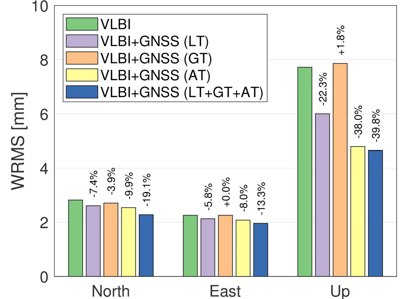
- Wang, J., Ge, M., Balidakis, K., Glaser, S., Heinkelmann, R., Schuh, H. (2025) Integrated Processing of GPS and VLBI at the Observation Level. Journal of Geodesy, 99, 60. doi.org/10.1007/s00190-025-01984-0
- Du, S., Cui, B., Tang, L., Wang, J., Huang, G., Schuh H. (2025) Enhancements of triple-frequency signals and multi-constellation combinations in PPP-RTK Services: improving convergence speed and expanding service coverage. GPS Solut, 29, 126. doi.org/10.1007/s10291-025-01883-z
- Wang, J., Balidakis, K., Dobslaw, H., Männel, B., Ge, M., Heinkelmann, R., Schuh, H. (2025). Correcting non-tidal atmospheric and oceanic loading displacements at the observation, normal equation, and parameter levels in GNSS Data analysis. Journal of Geophysical Research: Solid Earth, 130, e2024JB030299. doi.org/10.1029/2024JB030299
- Ding, J., Chen, W., Chen, J., Wang, J., Zhang, Y., Bai, L. (2025) Real-time high-resolution global PWV retrieval based on weather forecast foundation models and cross-validation with radiosonde, GNSS, and ERA5. IEEE Journal of Selected Topics in Applied Earth Observations and Remote Sensing.doi.org/10.1109/JSTARS.2025.3580782
- Ding, J., Chen, W., Chen, J., Wang, J., Zhang, Y., Bai, L., Wang, Y., Mi, X., Liu, T., Wenig, D. (2025) Spatiotemporal inhomogeneity of accuracy degradation in AI weather forecast foundation models: A GNSS perspective. International Journal of Applied Earth Observation and Geoinformation, 139. doi.org/10.1016/j.jag.2025.104473
- Wang, J., Chen, J., Zhang, Y. (2025) Empirical modeling of tropospheric delays and uncertainty. Geoscientific Model Development, 18, 1487–1504. doi.org/10.5194/gmd-18-1487-2025
- Yuan, P., Balidakis, K., Wang, J., Xia, P., Wang, J., Zhang, M., Jiang, W., Schuh, H., Wickert, J., Deng, Z. (2025). Deep neural networks for refining vertical modeling of global tropospheric delay. Geophysical Research Letters, 52. doi.org/10.1029/2024GL111404
- Cui, B., Wang, J., Li, P., Hu, J., Zuo, X., Tang, L. (2025). Modified ionosphere delay fitting model with atmosphere uncertainty grids for wide-area real-time positioning. Geo-Spatial Information Science, 1–19. doi.org/10.1080/10095020.2024.2440091
- Nie, L., Wang, J., Tang, L., Ge, H., Ge, M., Schuh, H. (2025). Impact of LEO configuration on GPS precise orbit determination with un-differenced ambiguity resolution. GPS Solut, 29, 28. doi.org/10.1007/s10291-024-01791-8
- Ding, J., Mi, X., Chen, W., Chen, J., Wang, J., Zhang, Y., Awange, J., Soja, B., Bai, L., Deng, Y., Tang., W. (2024). Forecasting of Tropospheric Delay Using AI Foundation Models in Support of Microwave Remote Sensing. IEEE Transactions on Geoscience and Remote Sensing, 62, 1-19. doi.org/10.1109/TGRS.2024.3488727
- Ding, J., Chen, J., Wang, J., Zhang Y. (2024). A novel method for tropospheric delay mapping function vertical modeling. J Geod, 98, 37. doi.org/10.1007/s00190-024-01845-2